Author:
Lisa Stannis, Director of Customer Development at Sharper Shape
Date
07/01/2025
 PDF
PDF

Click image to enlarge
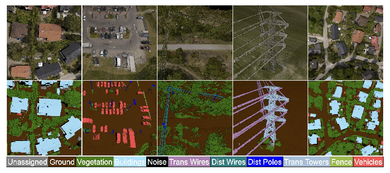
Figure 1: High accuracy LiDAR Classification excels in dense distribution network areas
Meeting today’s demands for resilience, safety, and efficiency requires accurate, timely, and scalable data about physical assets. One technology that is rapidly redefining how utilities manage infrastructure is LiDAR (Light Detection and Ranging).
LiDAR captures millions to billions of high-resolution, three-dimensional data points—called point clouds—that precisely map utility networks and their surrounding environments. From power lines to substations to surrounding vegetation, LiDAR offers detailed visibility that supports planning, maintenance, and emergency response.
But capturing LiDAR data is only half the job. The true value lies in how it’s classified—turning those raw, unstructured points into actionable insights.
Why LiDAR Classification Matters for Utilities
Raw LiDAR point clouds lack semantic meaning. Each point represents a location in space but doesn’t inherently say whether it belongs to a power line, a tree, a pole, or the ground. Classification is the process of assigning these labels, making it possible to analyze assets, assess risk, and make decisions.
For electric utilities, classification enables critical operations:
Without accurate classification, even the highest-resolution LiDAR data is just a cloud of points.
The Traditional Approach—and Its Limits
Historically, classification has relied on rule-based algorithms, statistical models, and manual annotation. Analysts apply filters and heuristics to segment terrain, detect structures, and label features. While this works for smaller datasets or simple landscapes, it doesn’t scale well to high-density, multi-terrain utility environments.
Traditional methods rely heavily on manual processing, which can take several months to complete. To reduce costs, this work is often outsourced overseas, introducing potential cybersecurity risks associated with transferring sensitive data across international boundaries.
Today’s LiDAR acquisitions often span hundreds of square miles and include billions of points. Manually classifying this data is not only time-consuming—it’s cost-prohibitive. Even semi-automated tools require extensive human review and correction, especially in cluttered or variable terrain.
In short, traditional workflows are hitting their limits. That’s where artificial intelligence (AI) steps in.
AI-based LiDAR classification, especially through deep learning, has significantly improved both the speed and precision of point cloud analysis. Instead of relying on hard-coded rules, AI models learn patterns directly from labeled data, identifying subtle geometric and reflectivity-based features across vast datasets.
Deep learning models offer significant advantages in LiDAR classification by distinguishing between overlapping or similarly shaped objects—such as wires and branches—detecting small or partially obscured infrastructure elements and adapting to diverse environments with minimal reprogramming. These models also scale efficiently, enabling the processing of massive datasets in a matter of hours rather than weeks, making them ideal for large-scale utility applications.
Choosing the Right Classification Tool: Key Considerations
LiDAR classification tools vary in how they process and interpret point cloud data—differences that can impact how electric utilities manage assets, assess risk, and plan infrastructure. Some tools use automated algorithms, including AI, to quickly classify features like power lines, poles, and vegetation. Others offer manual or semi-automated options, allowing for greater control in complex environments but take a significant amount of time to classify. Choosing the right tool depends on the utility’s specific needs—such as data volume, terrain complexity, and the level of precision required. Understanding these options is key to making classification workflows faster, more accurate, and more cost-effective.

Click image to enlarge
When selecting a LiDAR classification tool, it is essential to prioritize features that enhance both efficiency and accuracy. AI-driven algorithms that automatically classify points—such as ground, vegetation, and infrastructure—are crucial for processing large datasets quickly. While manual or semi-automated methods offer greater control, they are often too time-consuming for large-scale projects. Tools that include advanced feature extraction capabilities provide deeper insights into the data and enable more sophisticated classification. Additionally, the ability to segment point clouds into meaningful categories like buildings, vegetation, and ground is vital for ensuring classification accuracy.
Accuracy verification is another key aspect, as automated tools, while fast, may struggle in complex environments. A hybrid approach that combines automated classification with manual corrections helps maintain both speed and precision. Visualization features are also critical, allowing users to transform raw LiDAR data into interactive 3D models that are easier to interpret. This enhances analytical capabilities and improves decision-making based on the data. As AI continues to advance, its integration into LiDAR classification tools is revolutionizing the field by improving automation, enabling semantic segmentation, and expanding the scope of LiDAR applications across industries.
Challenges of AI in LiDAR Classification
AI is a powerful tool for LiDAR classification, but it comes with its own set of challenges. One major hurdle is the need for large volumes of accurately labeled training data. For utility-specific applications, this data is often scarce and costly to annotate. Additionally, AI models trained in one type of environment—such as urban areas—may not generalize well to others like mountainous or forested regions, often requiring retraining to maintain accuracy. The complexity of developing, validating, and maintaining these models also presents a barrier, as it typically demands specialized expertise that may fall outside the capabilities of many utility teams.
Another challenge is some feature classifications (e.g., custom infrastructure types or rare anomalies) still require manual workflows or expensive custom software. While off-the-shelf AI tools are becoming more accessible, industry-specific applications still demand tailored solutions.
Despite these challenges, AI-driven innovation is rapidly transforming how LiDAR data is processed. Modern workflows now include automated quality assurance and quality control (QA/QC) systems that can flag anomalies or inconsistencies during data processing, significantly improving reliability. Point cloud alignment and registration are also handled automatically, reducing setup time and minimizing manual intervention. Additionally, dynamic model updates allow new data to be integrated into existing models without the need to reprocess entire datasets, enabling faster, more efficient updates and continuous improvement in classification accuracy.
The result? Utilities get clean, actionable data faster—with fewer manual bottlenecks.
Click image to enlarge
Future Outlook: AI + LiDAR + Utilities
AI is reshaping LiDAR’s role in utility operations. As models become more accurate and tools increasingly user-friendly, the process of classification is transitioning from a manual task to a fully integrated, automated workflow. Future developments are expected to include predictive modeling, where historical point clouds are used to forecast vegetation growth, structural fatigue, or fire risk. Edge processing will enable AI models to run directly on drones or mobile platforms, allowing for real-time classification in the field. Additionally, integrated asset systems will allow classified LiDAR data to seamlessly sync with GIS, inspection, and maintenance platforms.
As sensor costs continue to decline and AI tools mature, LiDAR technology will become more accessible to a broader range of utility providers—from large transmission operators to smaller municipal services. This democratization of technology will support the development of smarter, safer, and more resilient energy networks, enabling proactive infrastructure management and improved service delivery across the utility sector.
Conclusion: Smarter Data for a Smarter Grid
AI-powered LiDAR classification is no longer a luxury—it’s becoming a necessity for modern electric utilities. With growing infrastructure demands, increasing environmental risks, and limited field resources, having a fast, accurate, and scalable classification process is critical.
By understanding the tools available and embracing intelligent automation, utility companies can move beyond reactive maintenance to predictive, data-driven decision-making. That’s not just an upgrade — it’s a transformation.