Connected cars and the IoT technologies driving society beyond mobility
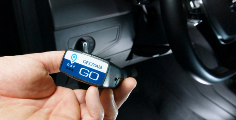
Figure 1. The GO9 device allows you to lead your fleet into the future with expanded capacity for further native vehicle support, improved fuel usage support, electric vehicles and global expansion. Geotab’s technology transforms big data into Smart Data to create Smart ecosystems, which turn into Smart Cities.
Since the introduction of the mechanical assembly line by Henry Ford more than a century ago, vehicles and technology have shared a long and inextricable history of automation, with continuous innovation not only central to the evolution of automobile design but also essential to advancing the smart city revolution taking place across the globe. With a sharp focus on improving urban mobility, increasing safety and reducing pollution, pioneering public, private and government organizations are turning to Internet of Things (IoT) technologies—and connected vehicles—to tackle some of the most challenging issues facing society.Though connected cars are not yet ubiquitous, most vehicles today are equipped with some wireless capability. While newer and recent-year vehicles are shipped with an embedded, factory-installed connected vehicle system, even older vehicles typically have the ability to connect via a self-contained aftermarket software and hardware telematics device that is easily installed into a vehicle's OBDII (on-board diagnostics) port. Moving forward, however, connectivity will only increase. In its inaugural connected vehicle forecast, International Data Corporation (IDC) examined the global and U.S. connected vehicle market for the 2018–2023 period and estimated that, by 2023, nearly 70 percent of worldwide new light-duty vehicles and trucks will be shipped with embedded connectivity. In the U.S., IDC expects nearly 90 percent of new vehicles shipped to include embedded connectivity by 2023.
Vehicles Connecting to Infrastructure
An IoT communication system, Vehicle-to-Infrastructure (V2I) is one of several connected car technologies enabling new solutions to improve the way we live, work and commute. Consider Washington D.C., which is ranked by INRIX ahead of Los Angeles and New York City for traffic congestion. With less than 1 million residents, it has one of the highest ratios of traffic signals per square mile at 26.06 (LA has only 8.78), resulting in constant gridlock. Using V2I communications systems, the District Department of Transportation (DDOT) aims to advance its mission to “enhance the quality of life for District residents and visitors by ensuring that people, goods and information move efficiently and safely, with minimal adverse impact on residents and the environment.” Enabling the sharing of data between connected vehicles and sensors embedded in critical elements of a city’s infrastructure—traffic lights, lane markers, streetlights, signage and parking meters among other things—V2Iis empowering decision makers and drivers with real-time information that has the potential to relieve congestion while advancing the District’s goal to reduce traffic-related deaths to zero. Equipped with cameras and sensors, smart traffic lights, for example, can detect whether one or many cars are waiting in specific lanes. Using this information, calculations are quickly run to determine the amount of time it will take to clear lanes. Smart signals can also communicate with other nearby smart signals or connect to the grid as a network of signals, working in tandem to improve traffic flow. These signals can also respond intelligently to data received from connected vehicles and mobility apps to warn drivers that they are about to drive through a red light or sense when a pedestrian is arriving and activate the crosswalk. V2Itechnology is also designed to improve the parking experience, with connected parking spaces communicating to the vehicle which spots are available. This technology reduces parking frustration for vehicle owners while simplifying occupancy tracking and beyond for parking lot attendants.
Click image to enlarge
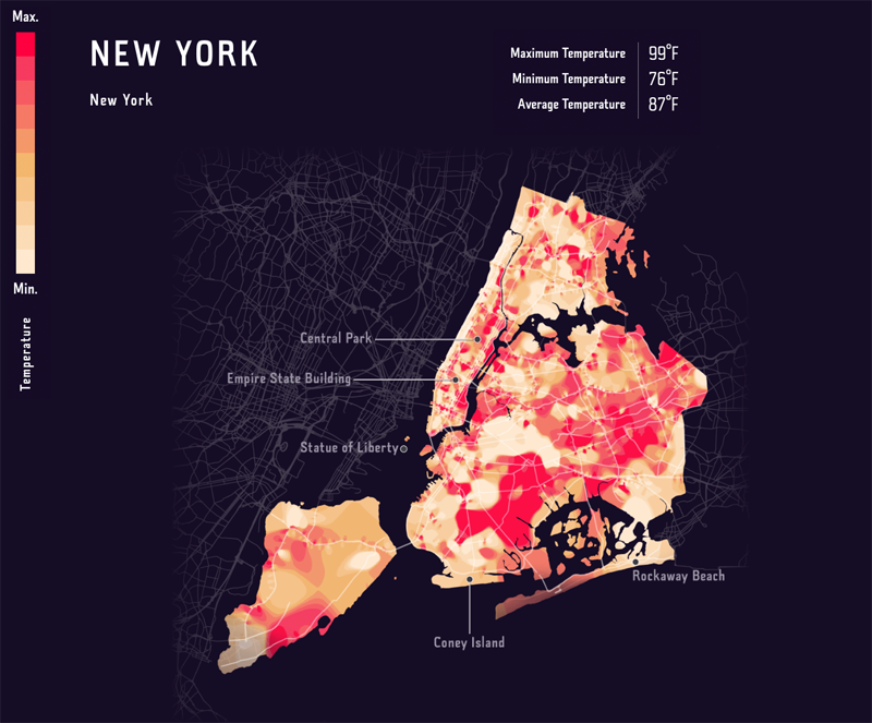
Figure 2. Heatmap depicting temperature in New York city via sensor network over the course of one day – Geotab’s solutions capture 30 billion data points per day across the world.
Vehicles Connecting to Vehicles
Vehicle-to-Vehicle (V2V) is another significant connected car technology shaping the future of intelligent transportation and smart cities. Current cutting-edge ultrasonic, radar and camera technologies that allow a vehicle to see and analyze its surroundings and make safe decisions while driving rely mostly on sensors, which have limited range. When it comes to hidden objects and unexpected behavior from other vehicles, these systems run into the same problems as humans do—although they react much quicker. V2V communications systems can correct this weakness by letting cars speak with one another directly and share information about their position, speed and status. With intersection movement assist (IMA), left turn assist (LTA) and the ability to see farther and enhance the level of predictability, V2V technologies are expected to have a big impact on road safety.
Vehicles connecting to everything
Vehicle-to-Everything communications, or V2X, combines V2I, V2V, V2P (vehicle-to-pedestrian) and V2N (vehicle-to-network, which connects to cellular infrastructure and the cloud) and extends those benefits to others on the roadway. With Wi-Fi and 5G serving as the backbone, V2X enhances automation with capabilities that will further improve safety and transportation infrastructure. Functions include:
● Informing autonomous vehicles of out-of-sight vehicles
● Warning distracted pedestrians of oncoming traffic
● Delivering alerts for weather and road conditions to drivers
Trial V2X projects are well underway across America in places such as Las Vegas, Utah and Georgia, where a pilot program was launched halfway between Atlanta and Montgomery, Alabama, along an 18-mile stretch of Interstate 85 known as The Ray, named after industrial sustainability champion Ray C. Anderson. According to technology partner Panasonic, the section serves as a “living laboratory for technologies that make driving safer, smarter and more sustainable” and a “proving ground for reinventing what a highway could and should be.”
Connected car data communicating through a central telematics hub
Central to V2X connectivity, telematics provides a central hub for all connected car data. Though the technology has been available for decades, the latest in-cab systems are state of the art and designed to rapidly collect and transfer consistent telemetry data via V2V and V2I engagement. Today, telematics systems are being deployed for a wide range of initiatives in municipalities and states across the U.S. In September 2019, the State of Colorado’s Division of Capital Assets (DCA) announced plans to roll out a fully integrated Electric Vehicle (EV) fleet management solution to accelerate Colorado’s transition to clean energy and support the State’s Electric Vehicle Plan. Equipping government vehicles with a cutting-edge telematics platform that tracks and measures fleet efficiency, as well as conventional fuel and electricity consumption, the DCA will ensure more reliable, environmentally responsible and cost-effective fleets as the state works toward combating climate change, reducing pollution and modernizing grid infrastructure. The State of California also implemented a telematics solution as part of its goal to promote reliable, environmentally responsible and cost-effective state, municipal and county fleet while supporting several green initiatives targeted at improving fleet operations and reducing harmful environmental impact. By giving regional governments unprecedented access to a leading-edge computing and analytics platform, these states and others will have the ability to put connected-vehicle data to use within a myriad of smart city and smart state initiatives.

Click image to enlarge
Figure 3. MyGeotab is a web-based fleet management software that reports fuel usage and consumption, driver safety, road & safety risks and needed vehicle maintenance.
In the same way the audacious idea of replacing the American horse and buggy with the Model T evolved beyond what Henry Ford likely imagined, future generations of connected vehicles will inevitably be designed to do far more for than transport people from one place to another. Embedded with IoT technologies, these “sensors on wheels,” with real-time data sharing at the core, could collect and process helpful information to improve every aspect of society. As a result, traffic jams, accidents, mobility challenges and perhaps pollution will one day become a thing of the past. In the meantime, we collectively have a shared responsibility and an opportunity to find solutions that drive civilization forward.
Geotab, Inc.